Capture reality on your terms
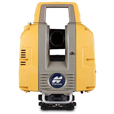
The GLS-2200 scanners consist of three comparable yet
distinct models: the GLS-2200S (short-range), GLS-2200M
(medium-range), and GLS-2200L (long-range). Each model
is a full-featured scanner that can be effectively deployed
to capture existing, as-built conditions based on the
measurement range requirements of the application. The
innovative capabilities of the GLS-2200 combined with its
rugged field design, provide users with a purposeful solution
that will stand up to the most extreme work environments.
Versatile and adaptable
The GLS-2200 offers quick, simple and effective ways
of capturing 3D point cloud data at high speed without
sacrificing the accuracy desired by today’s demanding
professionals. With one-button to start scanning, on-board
enabled occupation, and backsight orientation features,
along with MAGNET®
Collage software – the GLS-2200
portfolio provides a solution suited to any industry professional
wanting the most value from their scanning investment.
Dual cameras – wide-angle and zoom
Equipped with dual 5 megapixel cameras, including a 170°
wide-angle camera that obtains images at high speed and
an 8.9° telephoto camera that is coaxial with the measuring
axis, the GLS-2200 is ready to capture every detail.
Precise Scan Technology II
With three times faster (time-of-flight) pulse signals than
previous GLS models, the GLS-2200 produces a clear
signal waveform for more precise signal processing.
Employing an ultra-high-speed ADC (analog-digital
converter) along with a direct sampling technique, Precise
Scan Technology II enables signal extraction resulting in
reduced noise and high-accuracy data.
Dynamic Digital Workflows
MAGNET Collage and
MAGNET Collage Web
A powerful, yet simple way to process and combine mass
data sets in one software environment, MAGNET Collage
makes it easy to manage your point cloud data. MAGNET
Collage Web is a web service for sharing and collaborating
with 3D point clouds.
Processing
point cloud data
After field work is complete, MAGNET Collage supports
importing, viewing, and cleaning of collected point cloud data
– providing multiple tools for registering, then geo-referencing
scans to survey control.
Export to industry
applications
Exporting clouds or objects to third-party design and
analysis applications is simple. Topcon offers seamless
workflows with third-party software.
Extracting
objects
Tools for creating and editing objects such as polylines,
meshes, edges, and planes are easily accessed. The region
selection tool is especially useful for isolating surfaces such
as roadways and building walls, floors, and ceiling